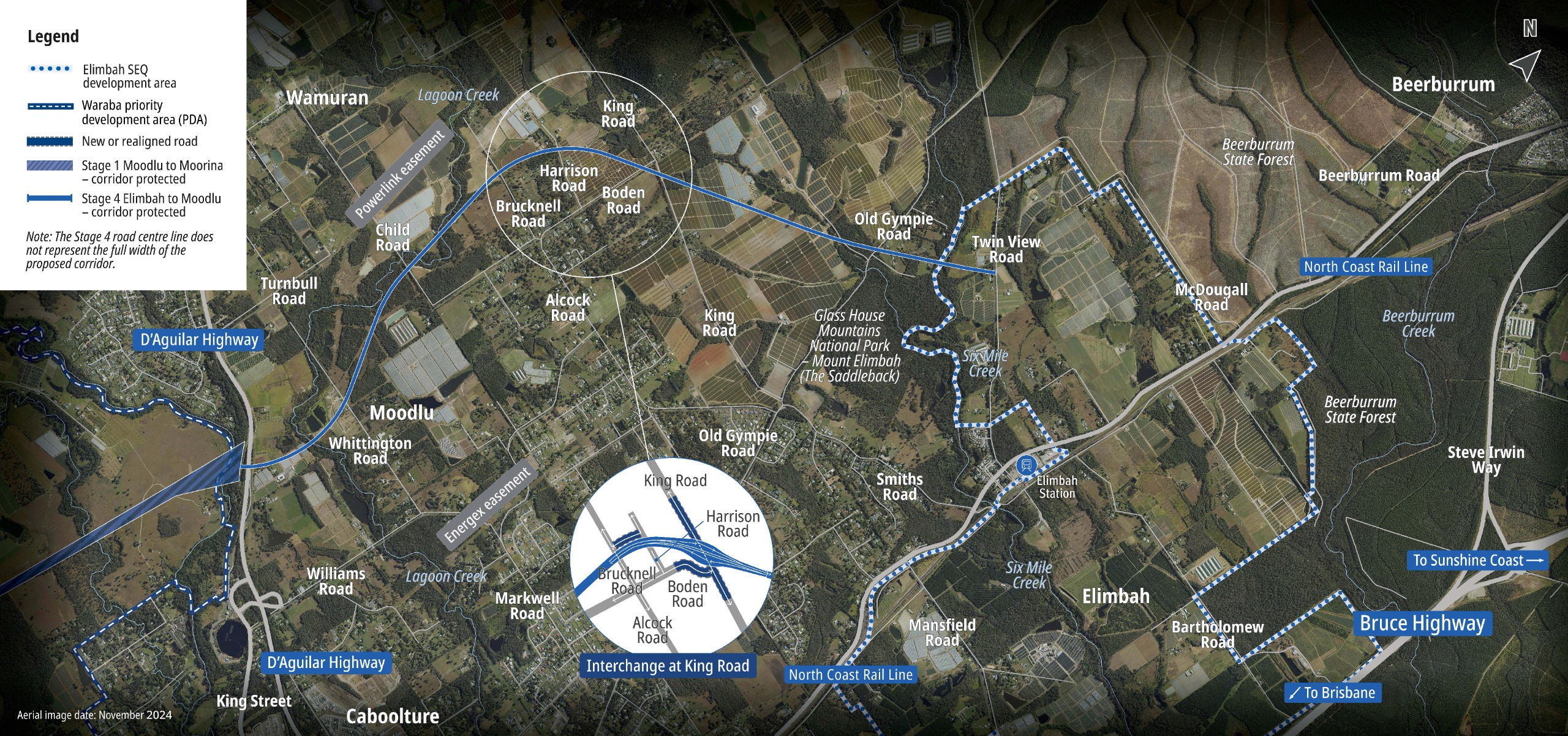
Beerburrum to Moodlu

The study area extends from the D’Aguilar Highway at Moodlu to Steve Irwin Way at Beerburrum. The area contains residential areas, rural residential zoned areas, agricultural land, state forest, national park, existing infrastructure (roads, utilities, rail, and community facilities), and the Elimbah SEQ development area outlined in ShapingSEQ 2023.

Community and stakeholder feedback was sought on a proposed alignment for Stage 4 from 19 March to 2 June 2025. TMR thanks the community for their valuable input and engagement on the project. All feedback is being considered as part of ongoing planning ahead of corridor protection. TMR will keep the community informed and provide an update once the feedback has been considered.

The proposed alignment

The 12.6-kilometre proposed alignment connects the D’Aguilar Highway at Moodlu to Steve Irwin Way at Beerburrum. It is west of the existing rural residential area and Elimbah township, travels through the north-west corner of the Elimbah SEQ development area, then heads east. State-owned forestry land is used in the northern part of the proposed alignment.

The proposed alignment mostly traverses rural land and is designed to minimise disruption by avoiding homes, buildings, and other structures, where possible.

It avoids Mount Elimbah (The Saddleback) and Mount Miketeebumulgrai and aims to reduce impacts on high-value vegetation and wildlife habitat.

Significant consideration has been given to major waterways, vegetation, and cultural heritage in the area. Interfaces with Lagoon, Six Mile and Beerburrum creeks, and their tributaries, have been sensitively designed to preserve riparian vegetation and minimise the risk of disturbing potential unknown cultural artefacts.

The alignment includes strategically placed interchanges at D’Aguilar Highway, King Road, and within the Elimbah SEQ development area. Bridges will maintain connectivity at Whittington, Child, Brucknell, Old Gympie, Twin View, and McDougall roads. Overpasses are proposed at Beerburrum Road and the North Coast Line rail corridor.

Space is preserved within the corridor for off-road active transport facilities, providing connection to walking and cycling networks. The corridor also has flexibility for public transport if required.

Key benefits

Compared to other alignments considered in the new investigations, key benefits of the proposed alignment include:

  • less impacts on farms and agribusiness
  • supporting the Elimbah SEQ development area
  • supporting expansion of the active and public transport networks
  • improving road network performance
  • lowering environmental impact, with fewer impacts on waterways, wildlife habitats and native vegetation
  • less impact on forestry plantation and the Beerburrum State Forest.

The proposed alignment has lower property impacts compared to the original alignment options and avoids areas zoned rural residential entirely.

Learn more in the planning summary and project newsletter.

Interactive maps

The 2 maps below have been used to show the features of the proposed alignment.

Section 1 shows the alignment from the D'Aguilar Highway to around King Road.

Section 2 shows the alignment from north of King Road to Steve Irwin Way.

Expand the images by clicking the arrows in the right-hand corner.

Have your say

Submissions on the Stage 4 proposed alignment closed on 2 June 2025. If you would like to provide feedback for consideration in future phases, please email NCR_Planning_Comms@tmr.qld.gov.au or phone 1800 955 799.

Section 1

Expand the image by clicking the arrows in the right hand corner.

Section 2

Expand the image by clicking the arrows in the right hand corner.